Another hurricane season is officially in the books, and like most years, there are some storms that come straight to the forefront when looking back on the last few months. Names like Florence and Michael won’t soon be forgotten.
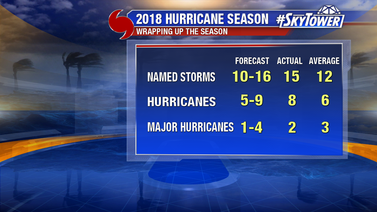
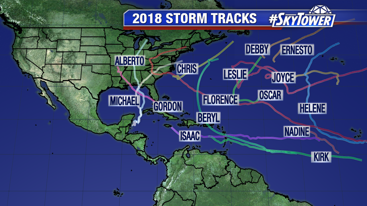
It ended up being a slightly above average year – 15 named storms overall, and it all got started with a preseason storm that affected Memorial Day weekend plans for many along Florida’s Gulf Coast. Subtropical Storm Alberto formed on the morning of May 25 in the western Caribbean. Forming before the official start of hurricane season, Alberto continued the recent spike of early-season tropical activity. Five out of the last seven years have featured a preseason (before June 1) storm – well above the average of one every three to four years.
The storm slowly strengthened as it moved north, eventually making landfall near Laguna Beach, FL (Bay County) on Memorial Day. It brought very gusty winds, heavy rain, and high surf to many popular holiday weekend destinations along Florida’s Gulf Coast.
While it was more of a nuisance storm, it was a reminder to be prepared. Little did we know at the time, Alberto was providing just a small taste of what was to come for the Florida Panhandle later in the season.
After a quick start, we waited about a month for our 2nd named storm of the season to form. Tropical Storm Beryl formed on July 5 in the Central Atlantic. One day later, it strengthened into the first hurricane of year – something that on average doesn’t happen August 10.
Beryl would ultimately succumb to high wind shear. The storm degenerated into an open wave before reaching the Leeward Islands. Its remnants brought gusty winds and some tropical downpours to parts of the eastern Caribbean before heading out to sea.
Just three days after Beryl formed, Tropical Storm Chris spawned a couple hundred miles off the coast of the Carolinas. It would go on to become our second hurricane of the season just two days later on July 10. Chris created high surf and rip currents for East Coast beach-goers, but it was ultimately ushered out to seas by an East Coast trough.
It was about a month and a half into the hurricane season, and with already three named storms – including two hurricanes – things were off to a hot start. Several weeks would then go by however with very little tropical activity. Debby and Ernesto formed in August, but both would simply be ‘fish storms’ in the North Atlantic. It may have been a quiet stretch, but the heart of the hurricane season was right around the corner.
Hurricane Florence
On September 1, a wave rolling off the coast of Africa became Tropical Storm Florence; and in the coming days went on to become the first major hurricane (Category 3+) of the 2018 season.
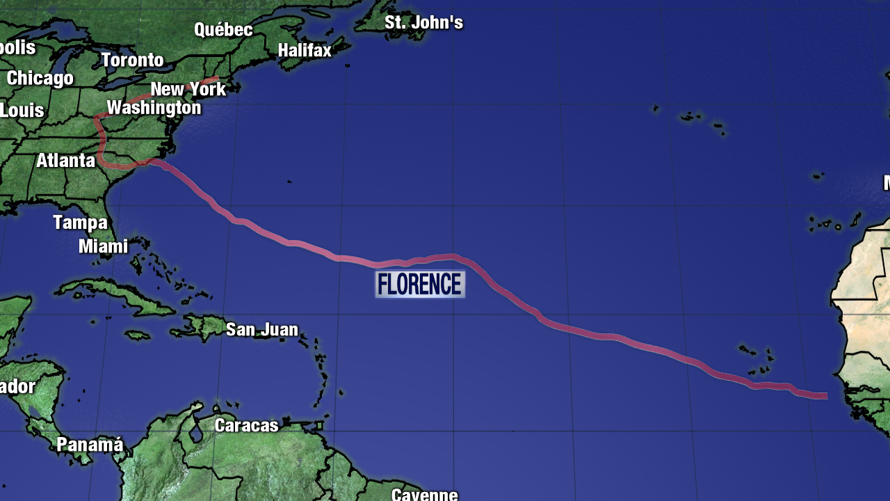
Above: Florence’s journey across the Atlantic
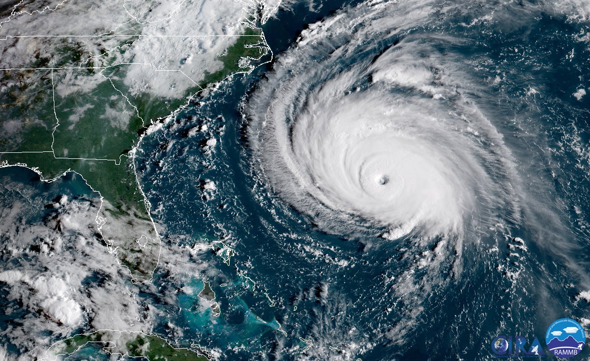
Initial thinking was that storm would find a weakness in the subtropical Ridge and make a northward turn as it moved across the Atlantic in the days surrounding Labor Day weekend. As the days went by however, it became increasingly clear that the steering flow over the Atlantic would send the storm further west, toward a possible encounter with East Coast of the U.S. A few hundred miles southeast of Bermuda, Florence actually weakened dramatically after encountering a pocket of high wind shear. As the storm drifted west, it then moved into an increasing favorable environment, strengthening from a tropical storm to a Category 4 hurricane with winds of 140 mph in just 48 hours. It was now on a collision course for the Carolinas and preparations quickly began.
Above: Florence making its final approach on the Carolinas
The storm slowed to a crawl as it neared the coast, eventually making landfall near Wrightsville Beach, NC on the morning of Friday, Sept 14. During this agonizingly slow approach, Florence weakened quite a bit. At landfall, max sustained winds were at 90 mph. While this weakening caused some to let to down their guard, the message conveyed by meteorologists all along was that flooding, not wind, would the biggest threat from Florence. Storm surge and heavy rainfall made for an incredibly dangerous situation. Over a three to four day period, Florence dumped up to nearly three feet of rain in some locations across the Carolinas. Rivers swelled and flooding that rivaled that of Hurricane Harvey (Texas/Louisiana 2017) lasted for weeks in the hardest hit areas.
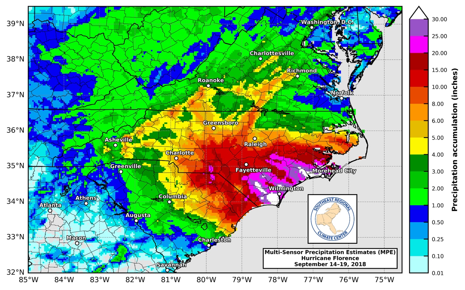
Above: Florence rainfall totals. Credit: Southeast Regional Climate Center
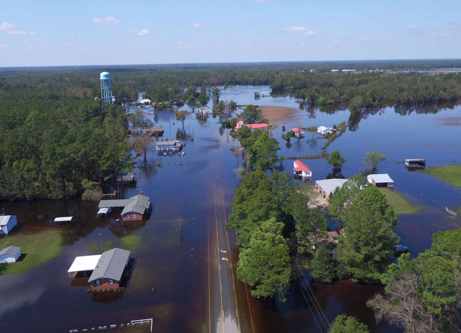
Above: Flooding in Chinquapin, NC. Credit: North Carolina Department of Aviation
Florence was the wettest tropical cyclone on record for the Carolinas, and the second wettest storm for the United States in the last 70 years. Roughly 10 trillion gallons of water fell across North Carolina and South Carolina. Workers who normally work on water damage in Burbank have volunteered their time to those in need in these areas. Acts of kindness during these disaster are so appreciated, no on can overstate them.
While Florence was making its way across the Atlantic in early September, Tropical Storm Gordon formed much closer to home as a tropical wave moved across the northern Caribbean toward South Florida. Once this disturbance crossed over the warm waters of the Gulf Stream and into the eastern Gulf, development and intensification happened quickly. The storm formed over Labor Day weekend near the upper Florida Keys. Heavy rain triggered flash flooding across parts of South Florida and Marco Island recorded a wind gust of 68 mph.
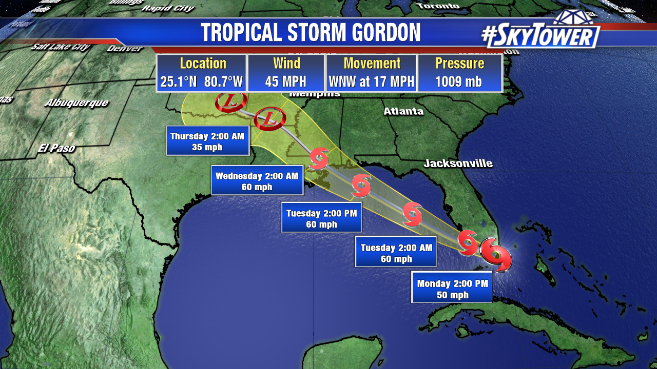
Thankfully, there was enough wind shear over the eastern Gulf to keep things in check as Gordon moved away from Florida and toward the northern Gulf Coast. It made landfall the day after Labor Day near the Mississippi/Alabama border as a strong tropical storm with max winds of 70 mph – just shy of hurricane strength. As much as 10” of rain fell across parts of Mississippi, Alabama, and the western Florida panhandle.
September would continue to be a very active month. Five more named storms formed the rest of the month… Helene, Isaac, Joyce, Kirk, and Leslie… really only two of which had any impact on land. Those two, Isaac and Kirk were both minimal tropical storms that brought some gusty winds and tropical downpours to the parts of the Lesser Antilles before dissipating over the Caribbean Sea due to high wind shear. Leslie was also notable purely because of its lengthy lifespan – looping around the Atlantic for three weeks before eventually losing its tropical characteristics and bringing some wind and rain to parts of Portugal and Spain.
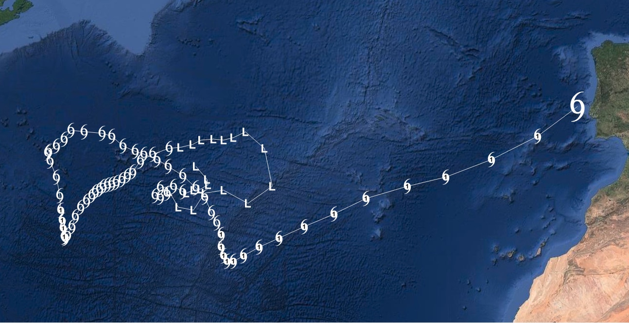
Above: Leslie’s 3 week journey around the Atlantic.
September would end with a total of seven named storms, bringing the season total to 12. Three of these had hit the U.S. mainland, but the worst was yet to come.
Hurricane Michael
October is the point of hurricane at which the focus shifts to more ‘home-grown’ tropical activity across the Gulf of Mexico and Caribbean Sea. Sure enough, in early October 2018, signs started to point toward possible tropical development in the western Caribbean. It quickly became apparent that a storm would form and head toward the northern Gulf Coast.
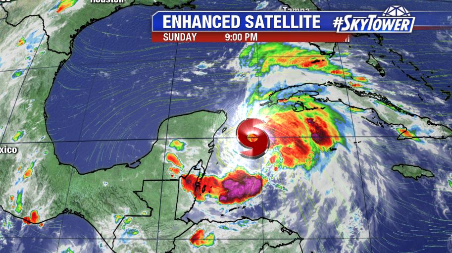
Above: Satellite view of Michael just a few hours after it became a tropical storm.
At this point in every hurricane season, there is often tremendous amounts of ocean heat content in this part of the world for storms to feed off of. Water temperatures in the Gulf of Mexico can soar well into the 80s, and loop current eddies forming off the Gulf Stream cause that warm water to extend to a greater depth. Hurricane Michael fed off this heat source, and quickly intensified from tropical storm to a major hurricane in just over 24 hours.
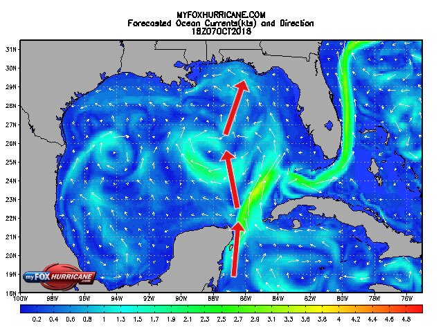
Above: Gulf Stream and Loop Current eddies in place as Michael moved north.
The storm made landfall on the afternoon of Wednesday, October 10th as an intense Category 4 hurricane with winds of 155 mph. The storm’s pressure at landfall was 919 mb, making it the third strongest hurricane on record (by pressure) to hit the U.S. mainland – only Hurricane Camille (1969) and the Labor Day Hurricane of 1935 were stronger.
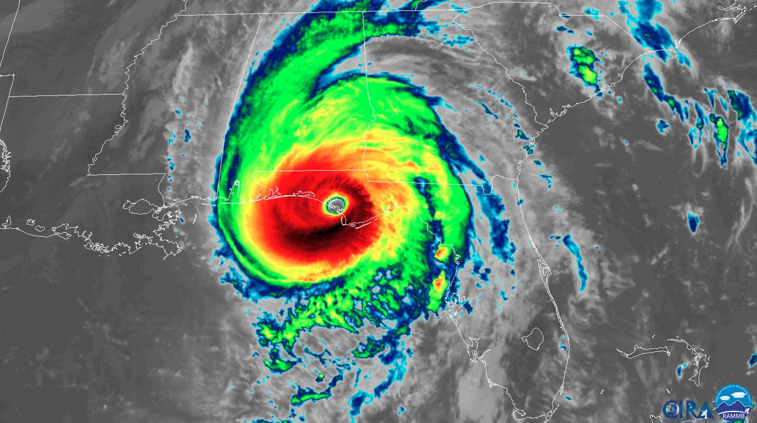
Above: Category 4 Hurricane Michael at landfall.
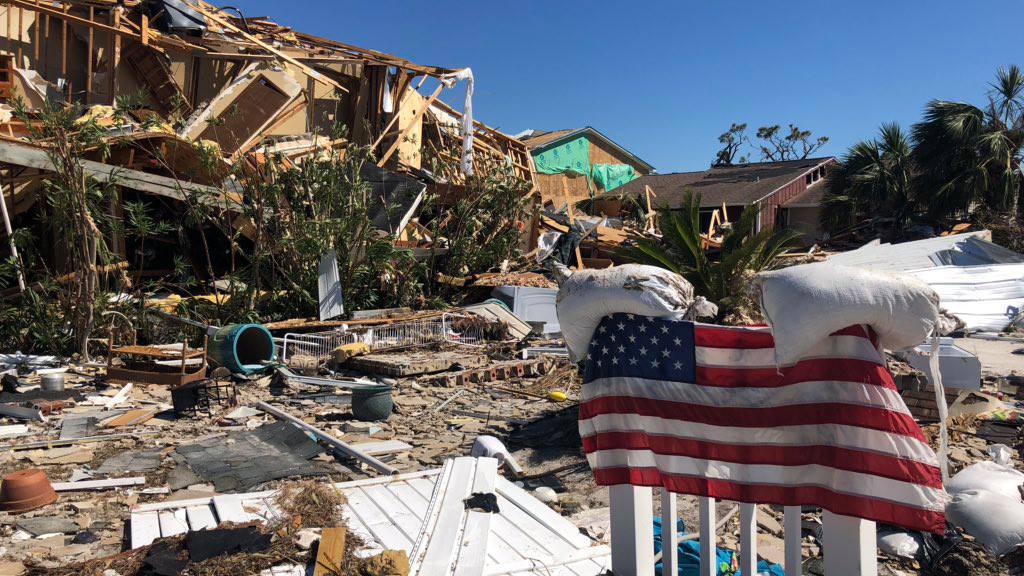
Landfall happened near Tyndall Air Force base just south of Panama City, FL. This created devastating storm surge in small seaside towns just east of Tyndall AFB like Mexico Beach, Port St Joe, Cape San Blas, and Apalachicola. A high water mark of 19 feet was measured after the storm in Mexico Beach.
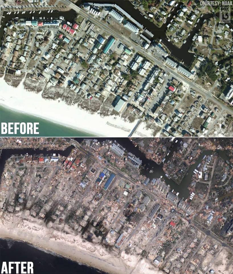
Above: Before and after satellite view of Mexico Beach, FL. Below: Damage in Mexico Beach
Wind damage was extensive, nearly wiping away every piece of vegetation from Panama City to Apalachicola. With such a powerful, quick moving storm, hurricane-force wind damage extended all the way up into southeast Alabama and southwest Georgia. In fact, as Michael crossed the border into Georgia, it was still a Category 3 hurricane – the first major hurricane in the state since 1898.
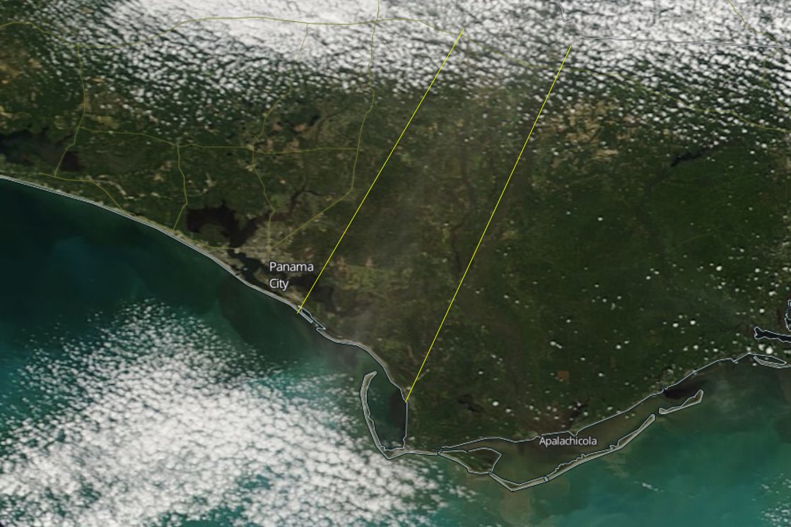
Above: Satellite view of NW Florida showing a ‘scar’ along the path of Michael’s core
Michael was the third Category 4 hurricane to hit the continental U.S. in just two years, which is a record. The storm was also a reminder of why need to be prepared before hurricane season begins. The time between the Michael’s formation and its landfall spanned only about 72 hours, leaving many folks in a tough position of scrambling to prepare last minute.
With such a ferocious storm causing such devastation, that last two storms of the 2018 season seem hardly noteworthy. Tropical Storm Nadine was another fish storm out in the middle of the Atlantic. Hurricane Oscar was the last storm to form – spinning up in late October and ultimately staying away from any landmasses as well.