Florence Strengthening Quickly; Helene and Isaac Ramping Up As Well

Florence became a hurricane again on Sunday morning and it won’t be looking back anytime soon. Rapid intensification is likely to occur over the next couple of days as the moves west-northwest through a very favorable environment. A category 4 hurricane within 48 hours is a likely possibility.

While there are still some questions regarding the exact track of Florence as it approaches the coast, the two most likely scenarios that model trends are leaning toward are 1) a northward turn with a storm either scraping or staying just offshore of the Outer banks of North Carolina and 2) a further southwest track with a direct landfall on the South Carolina or North Carolina coast. The important thing to remember here is that we are still at least 4 days from landfall. Things can and will change, and it will take a couple more days to iron out specific details. Obviously, folks with interests in these areas should be checking back frequently for updates.

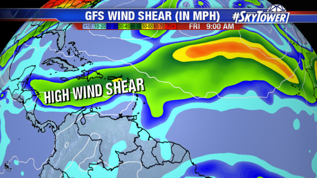
We also continue to keep any eye on Helene and Isaac. Helene is now a hurricane, and Isaac will soon gain that status as well. Both will continue to move west over the next couple days, but Helene should start to curve north by the middle of the week and should ultimately not pose a threat to anyone. Isaac on the other hand will be moving into the Caribbean by Thursday. Parts of the Lesser Antilles should see tropical storm or hurricane warnings issued at some point on Tuesday. Thereafter, the storm should encounter quite a bit of wind shear over the Caribbean and, as of right now, models don’t do a whole lot with it. Just something for us to babysit over the next week or so.

Florence, Isaac, Helene – All Likely to Become Hurricanes Early Next Week

Right now Florence, Isaac and Helene are still Tropical Storms, but they are all headed to more favorable environments and will likely become hurricanes by Tuesday.

Florence is the storm of most concern with impacts along the Carolina coastline looking more likely. The storm is becoming better organized and rapid intensification over the next 12-36 hours is expected, as Florence moves into warmer water and an area of lower wind shear. It could become a major category 4 hurricane by Wednesday.

Models are in good agreement as Florence moves west northwest in the Atlantic. They diverge as the storm nears the Eastern coast, with some even showing the system staying out in the Atlantic just offshore.

There is still uncertainty in the exact track, intensity and impacts to the east coast as the storm is still several days out. But those along the east coast should monitor the storm and have their hurricane preparedness plan in place.

Isaac and Helene will both enter into areas of lower wind shear and are forecast to strengthen into category 2 hurricanes. Isaac will head due west towards the Lesser Antilles, arriving around Thursday. There is an area of higher wind shear in the Caribbean Sea that Isaac will contend with as it continues to move west.  Helene will head away from the Cabo Verde Islands and into the open Atlantic, making a turn towards the north by midweek.