2020 NOAA Outlook Calls For Above-Normal Atlantic Hurricane Season

The National Oceanic and Atmospheric Administration (NOAA) released their 2020 season outlook on Thursday morning. It calls for a 60% chance of above-normal activity in the Atlantic basin, with the possibility of an ‘extremely active’ season.

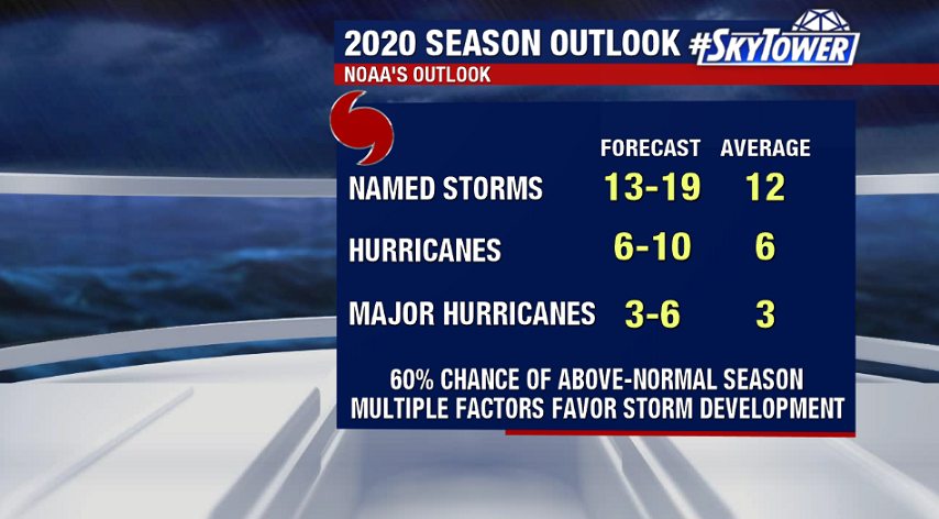
Several factors are expected to favor storm development including warm sea-surface temperatures (SSTs), weaker trade winds, weaker vertical wind shear, and a stronger African monsoon season. In addition, the El Nino-Southern Oscillation (ENSO) is expected to remain in a neutral phase through the summer, with possible weak La Nina conditions – cooler SSTs in the central/eastern Pacific – developing by the peak of the hurricane season. Historically, this favors above normal tropical activity in the Atlantic and would lead to the number of storms this season being closer to the high end of NOAA’s prediction.

As always, this really doesn’t change anything for us. We should be preparing the same way every year. Also, remember that this is a forecast for activity and says nothing about possible landfalls. We’ll be here with you every step of the way!

Tropical Storm Arthur Expected To Brush NC Coast Before Heading Out To Sea

As of 2pm Sunday, Arthur was located about 300 miles SSW of Cape Hatteras, NC. It will continue moving NNE over the next 24-48 hours while picking up forward speed. On the current track it will pass near or just east of the North Carolina coast on Monday. A tropical storm warning is in effect from Surf City to Duck, NC.

Arthur is a lopsided storm, with the worst of the weather on its eastern side. So, with the current track, the strongest winds should stay offshore. That being said, tropical storm force winds will still be possible along the immediate coast. In addition, 1-3″ of rain is likely for parts of coastal NC. It should be noted though that much of the Eastern U.S. will have quite a bit of rain around anyway over the next few days thanks to an upper-level spinning over the Southeast.

Arthur will continue to generate large swells along the Southeast U.S. coast up through the mid-Atlantic over the next 2-3 days, which may lead to rough surf and a high rip current risk for beachgoers.