Weak Low Moving Near Florida This Weekend; Tropical Development Possible

As we get set to close out the work week, we’re watching an area of disturbed weather central Cuba. The National Hurricane Center is currently giving this a 50% chance of development over the next few days as it moves northward and eventually up the east coast of Florida.

floater-satellite-radar-weekend-am

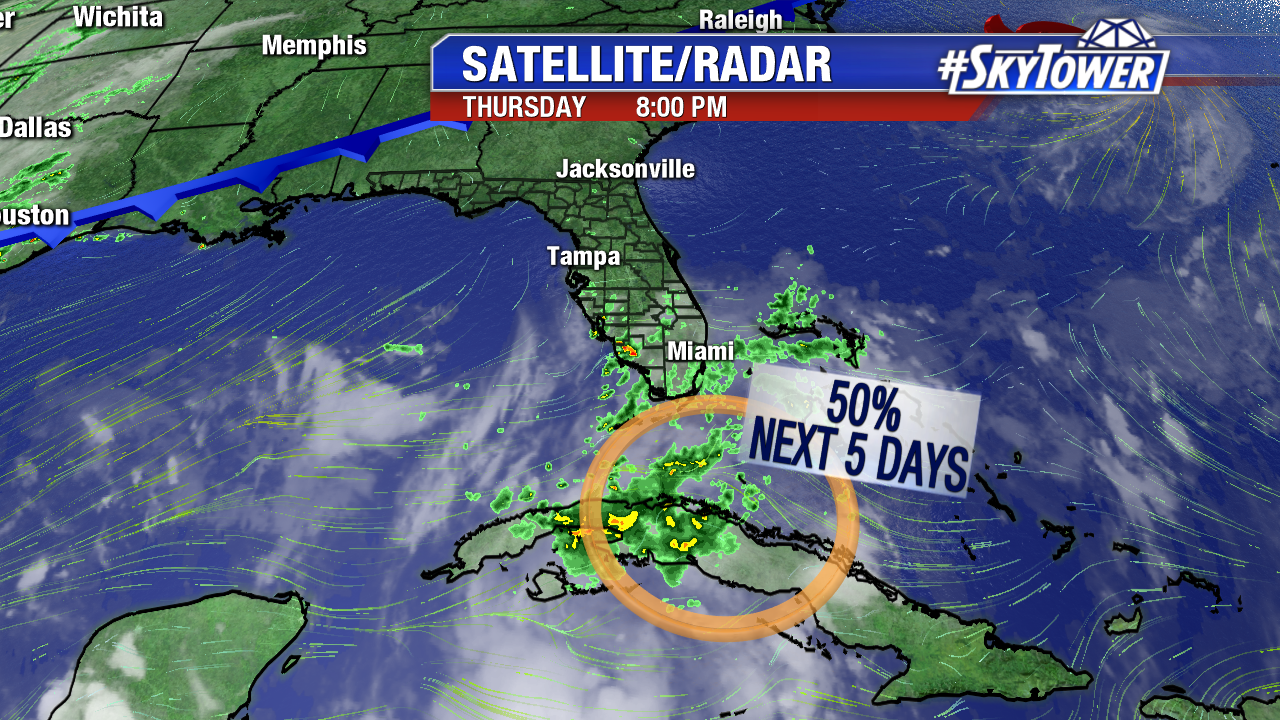
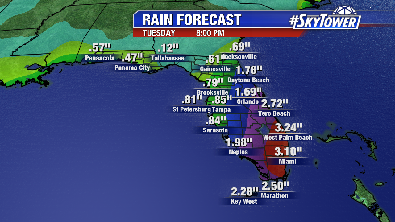
A weak area of low pressure is likely to form through the day on Friday as this disturbance moves over the Florida Straits. Any time you have an area of low pressure in a favorable environment over very warm water, it has to be watched closely. That being said, even if we do see something develop, it would likely be weak with minimal impacts. The one thing we can count on though is increased rain chances across most of the state through the weekend and into early next week. Rain totals will be on the order of 1-3″ across a lot of Central and South Florida, with isolated higher amounts possible especially in South Florida.

florida-ecmwf-precip-acc-with-plot

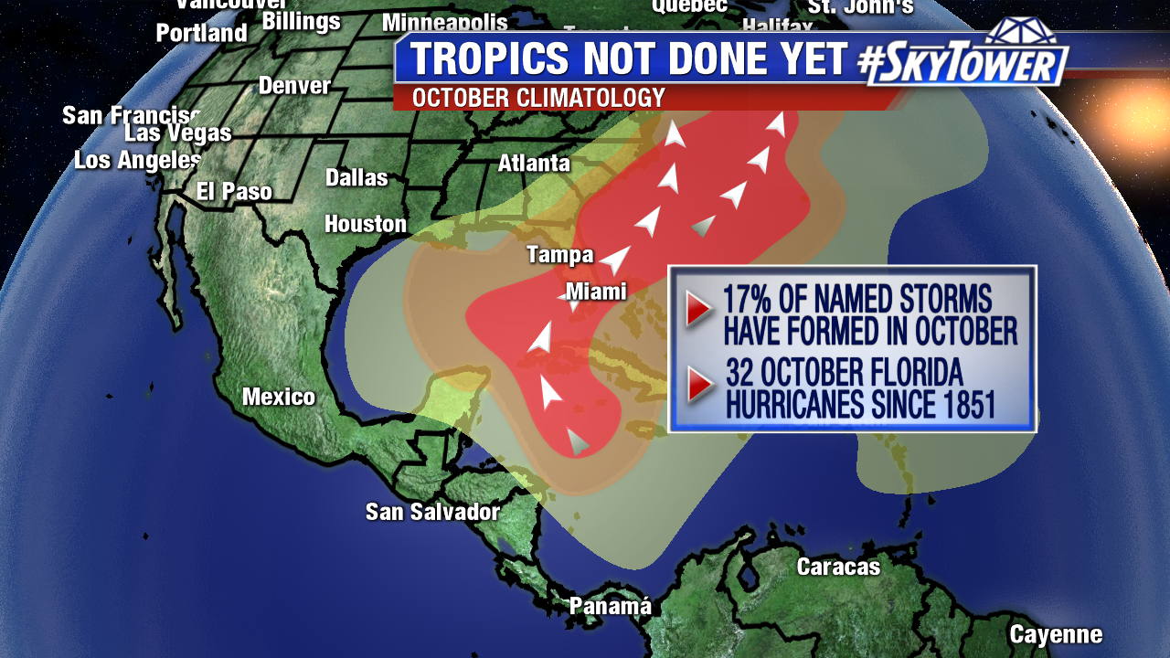
We’re getting into the time of year when ‘homegrown’ activity in the Gulf of Mexico and Western Caribbean become more prevalent. Fitting into that mold, many models as of late have hinted at lowering pressure across the western Caribbean late next week. It’s something you’ll hear us talk more about as we get closer to that time frame, but for now it is just reminder that hurricane season is not over and we need to stay prepared. Hopefully we’ll get through the next few weeks unscathed and we’ll be home free, as things quiet down greatly in November.

Maria Ready To Race Out To Sea; Looking Ahead To October

Overnight Tuesday into early Wednesday, Maria brought tropical storm conditions to the Outer Banks of North Carolina. The storm stayed about 150 miles offshore as it passed by, but large swells created dangerous rip currents and a storm surge of 2-4′, which in some cases resulted in minor coastal flooding.

peak-wind-gusts2 fastrac

Maria is a category 1 hurricane with winds of 75 mph as of 11am Wednesday. Thanks to a trough digging into the northeast, Maria will take a sharp right hand turn over the next 24 hours and begin moving rapidly to the east-northeast, out to sea. Subsequently, conditions along the east coast will slowly be improving.

invest-90l-models

atlantic-wide-2d-ir-enhanced

With Maria on its way out and Hurricane Lee bothering nobody but the fish in the open Atlantic, we finally have somewhat of a quiet period. That being said, it is still hurricane season and we’ll still be watching the tropics closely over the next month or so. Storms can and do often form during the month of October, before we see a sharp decline in activity in November. Unlike August and September, when we watch for tropical waves rolling off Africa, the month of October often favors more “homegrown” activity in the Caribbean and Gulf of Mexico. There have already been some hints in our long-range modeling of lowering pressure in the western Caribbean over the next couple of weeks. For now though, we enjoy the relative lull in activity and hope it stays with us the rest of the season.

climatology-october

It has been an incredibly active season thus far with 13 named storms, 8 hurricanes, and 5 major hurricanes – already nearing or reaching the numbers put forth in many seasonal outlooks, with still two months left in the official hurricane season.

2017-season-update