Weak Development Possible In The Central Atlantic; No Threat To Land

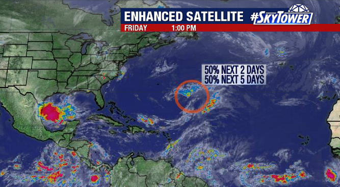
As of Friday afternoon, there’s a disturbance several hundred miles southeast of Bermuda producing a large areas of showers and thunderstorms. This will have a short window for additional development over the next day or two, and a subtropical depression may form tonight or on Saturday. Either way, there won’t be any threat to land as this will move generally northward before being picked up in a trough coming off the East Coast of the U.S Sunday into Monday.

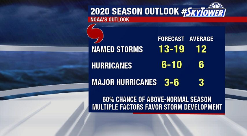
The 2020 Atlantic Hurricane Season will start on Monday, June 1. The next name on the list is Cristobal – as Arthur and Bertha already came and went over the last 2 weeks.

2020 NOAA Outlook Calls For Above-Normal Atlantic Hurricane Season

The National Oceanic and Atmospheric Administration (NOAA) released their 2020 season outlook on Thursday morning. It calls for a 60% chance of above-normal activity in the Atlantic basin, with the possibility of an ‘extremely active’ season.

Several factors are expected to favor storm development including warm sea-surface temperatures (SSTs), weaker trade winds, weaker vertical wind shear, and a stronger African monsoon season. In addition, the El Nino-Southern Oscillation (ENSO) is expected to remain in a neutral phase through the summer, with possible weak La Nina conditions – cooler SSTs in the central/eastern Pacific – developing by the peak of the hurricane season. Historically, this favors above normal tropical activity in the Atlantic and would lead to the number of storms this season being closer to the high end of NOAA’s prediction.

As always, this really doesn’t change anything for us. We should be preparing the same way every year. Also, remember that this is a forecast for activity and says nothing about possible landfalls. We’ll be here with you every step of the way!