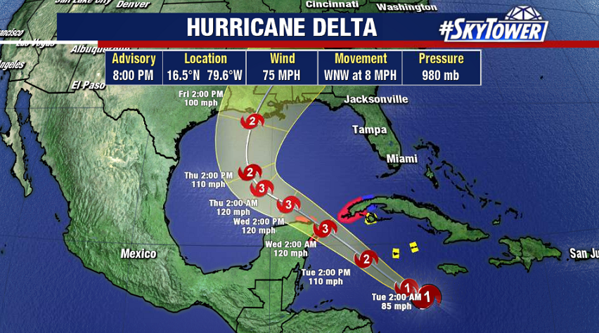
2020 NOAA Outlook Calls For Above-Normal Atlantic Hurricane Season

The National Oceanic and Atmospheric Administration (NOAA) released their 2020 season outlook on Thursday morning. It calls for a 60% chance of above-normal activity in the Atlantic basin, with the possibility of an ‘extremely active’ season.

Several factors are expected to favor storm development including warm sea-surface temperatures (SSTs), weaker trade winds, weaker vertical wind shear, and a stronger African monsoon season. In addition, the El Nino-Southern Oscillation (ENSO) is expected to remain in a neutral phase through the summer, with possible weak La Nina conditions – cooler SSTs in the central/eastern Pacific – developing by the peak of the hurricane season. Historically, this favors above normal tropical activity in the Atlantic and would lead to the number of storms this season being closer to the high end of NOAA’s prediction.

As always, this really doesn’t change anything for us. We should be preparing the same way every year. Also, remember that this is a forecast for activity and says nothing about possible landfalls. We’ll be here with you every step of the way!

Tropical Storm Arthur brushes North Carolina coast

Our first tropical system of the season is making a very close pass on the North Carolina coast line. Winds are sustained at 50mph but the majority of the wind and rain with this storm is on the eastern side or the side away from land. Arthur will begin to turn in an easterly direction over the next several hours as wind shear continues to increase. Winds are expected to increase as it begins to transition from a tropical system to a non-tropical low.

The strongest area of deep convection has remained offshore with some occasional rain bands wrapping around to the western side of the storm and moving onshore. Dry air has been wrapping around the southern side of the storm so virtually all the the convection has been limited to the northern half of the storm.

Winds have been gusting close to tropical storm force along the immediate coastline inside of some of the rain bands. With the quick forward speed of Arthur the rainfall amounts will be modest. The immediate coastal towns will see 1 to 3 inches of rainfall. Arthur is just another reminder of how as we “officially” start the hurricane season on June 1st, tropical systems can form prior to the start of the season and can form quickly.