Eta Makes Landfall In The Florida Keys; West Coast Of Florida On Guard This Week

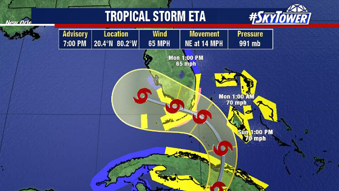
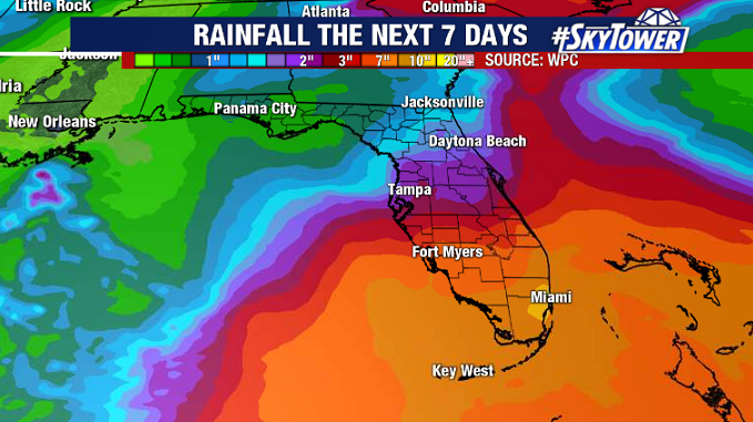
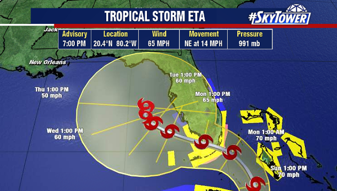
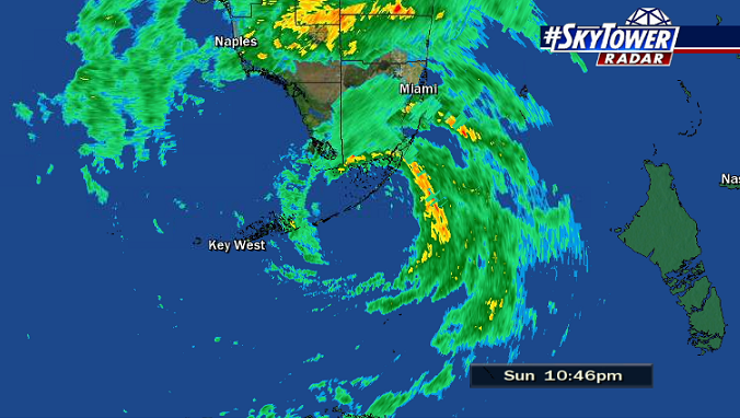
Tropical Storm Eta made landfall in the Keys near Islamorada at 11pm Sunday evening with max sustained winds of 65 mph. Strong onshore flow continues to push water onshore north of the center. This, along with persistent rainfall has already led to quite a bit of flash flooding across parts of southeast Florida. Rain will continue tonight and through at least the first half of Monday. Overall, expect a messy Monday all across central and south Florida, with periods of rain and gust winds as Eta moves west into the southeastern Gulf of Mexico.

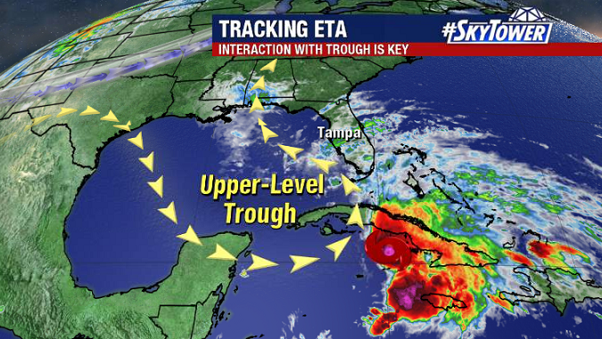
Steering flow is going to collapse as the storm moves into the Gulf and Eta is likely slowly meander, if not stall altogether, a couple hundred miles offshore during the first half of the week. While the storm is this far offshore, it will be a bit of a break for Florida. Breezy days with scattered showers can be expected Tuesday and at least part of Wednesday.

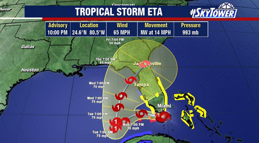
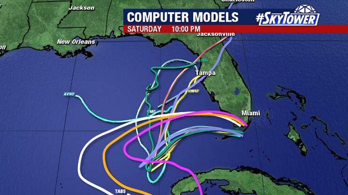
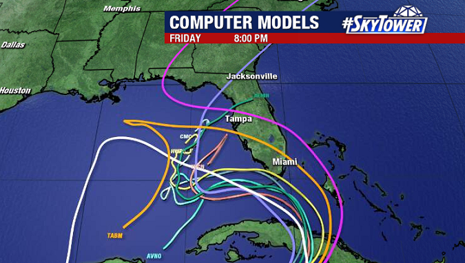
This is when things get interesting. There has been model support for the storm to get moving again and head toward Florida’s west coast on Thursday. This would obviously bring with it a variety of impacts including storm surge and coastal flooding, sustained tropical storm-force winds, nasty rain bands, and likely a tornado threat as well. This is not written in stone yet, but the potential is definitely there, and the likelihood of such an outcome is slowly increasing. You’ll want to check back with us often this week as we iron out the details.

Eta Headed For A South Florida Landfall On Monday; Still A Very Tricky Forecast

Tropical Storm Eta will be moving over Cuba tonight and begin making that sweeping left hand turn toward south Florida on Sunday afternoon. Landfall is likely in far SE Florida or the Keys Monday morning, at which point the storm will be near hurricane strength.

Tropical Storm warnings are in effect from Bonita Beach, down through the Keys, and up the east coast the the Jupiter Inlet. Folks in these areas need to be prepared for wind gusts as high as hurricane-force, coastal flooding, and heavy rainfall. Widespread totals of 6-12″, with isolated amounts up to 18″ will likely lead to additional flash flooding.

The forecast then gets pretty tricky. This big turn to the west is due to the storm wrapping around the trough parked over the Gulf of Mexico. Initially it appeared as though Eta would make a turn back to the north-northeast and make a second landfall along the west coast of Florida.

Recent trends however, show this trough/cut-off low absorbing Eta and stalling it over the southeastern Gulf for a few days. This is a much better scenario than a storm sweeping back across the state. We still need to watch this very closely and see how things evolve, but given what we know now, folks up through the Tampa Bay region should plan on some gusty winds and fast-moving showers on Sunday, followed by a wet and windy Monday with some gusts as high as 35 mph. It’s enough wind that you want to make sure you secure any pool chairs, trash cans, small potted plants, etc. but that’s about it.

If the storm does indeed park itself out in the Gulf a couple hundred miles away, scattered showers and gusty winds at times would linger through midweek, but generally speaking we would have gradually improving weather across central and south Florida through the week.