Tropical Storm Emily Makes Landfall on Anna Maria Island; Wet Monday in Central Florida

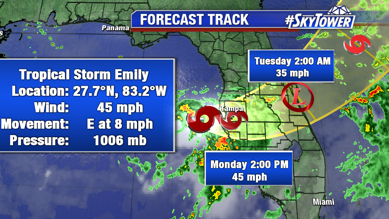
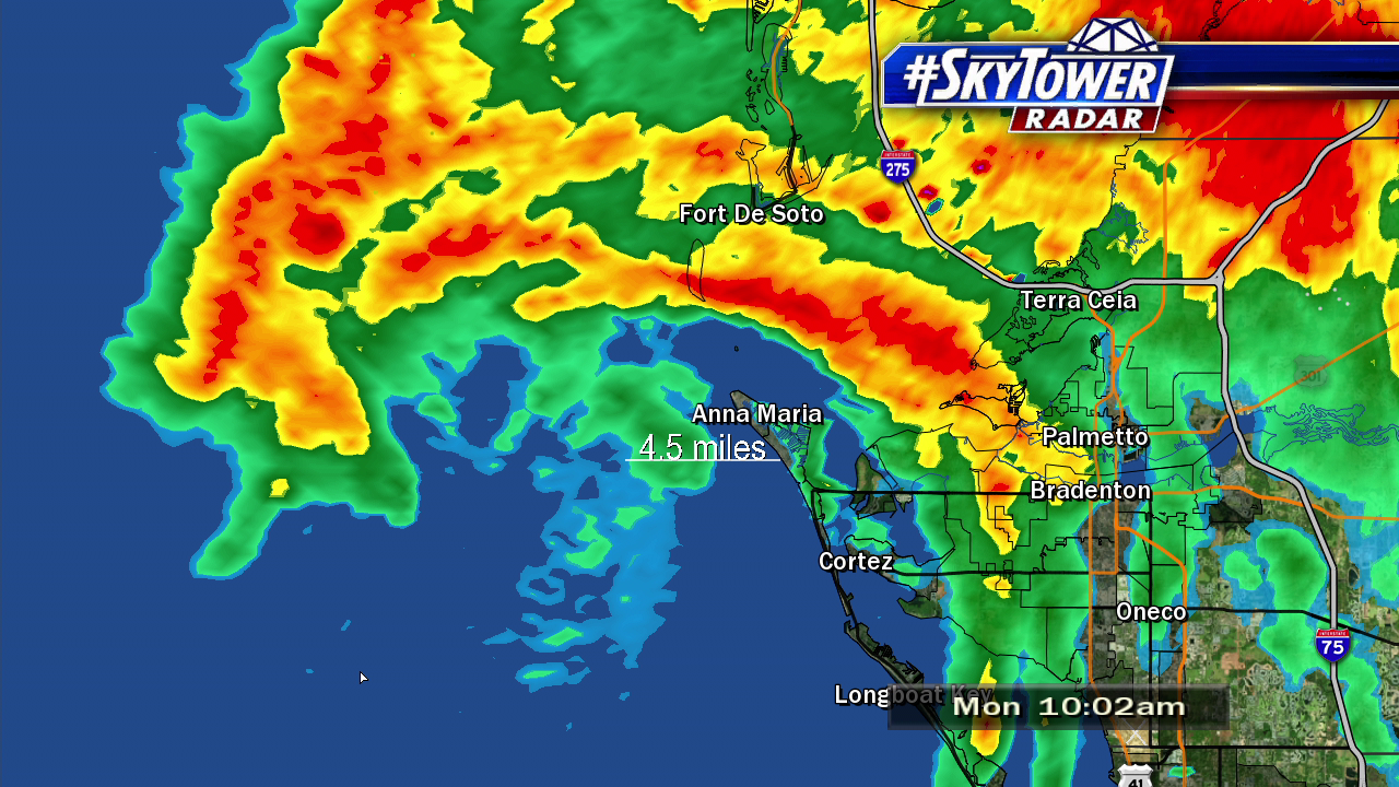
Tropical Storm Emily made landfall on Anna Maria Island at 10:45 AM Monday morning with 45 mph winds. Strong rotation northeast of the center was spotted near the Sunshine Skyway Bridge during the time, which prompted a Tornado Warning for Manatee county, including Bradenton.  As Emily moves further east away from the Gulf, it will weaken further Monday afternoon and evening.

vipir-png2323

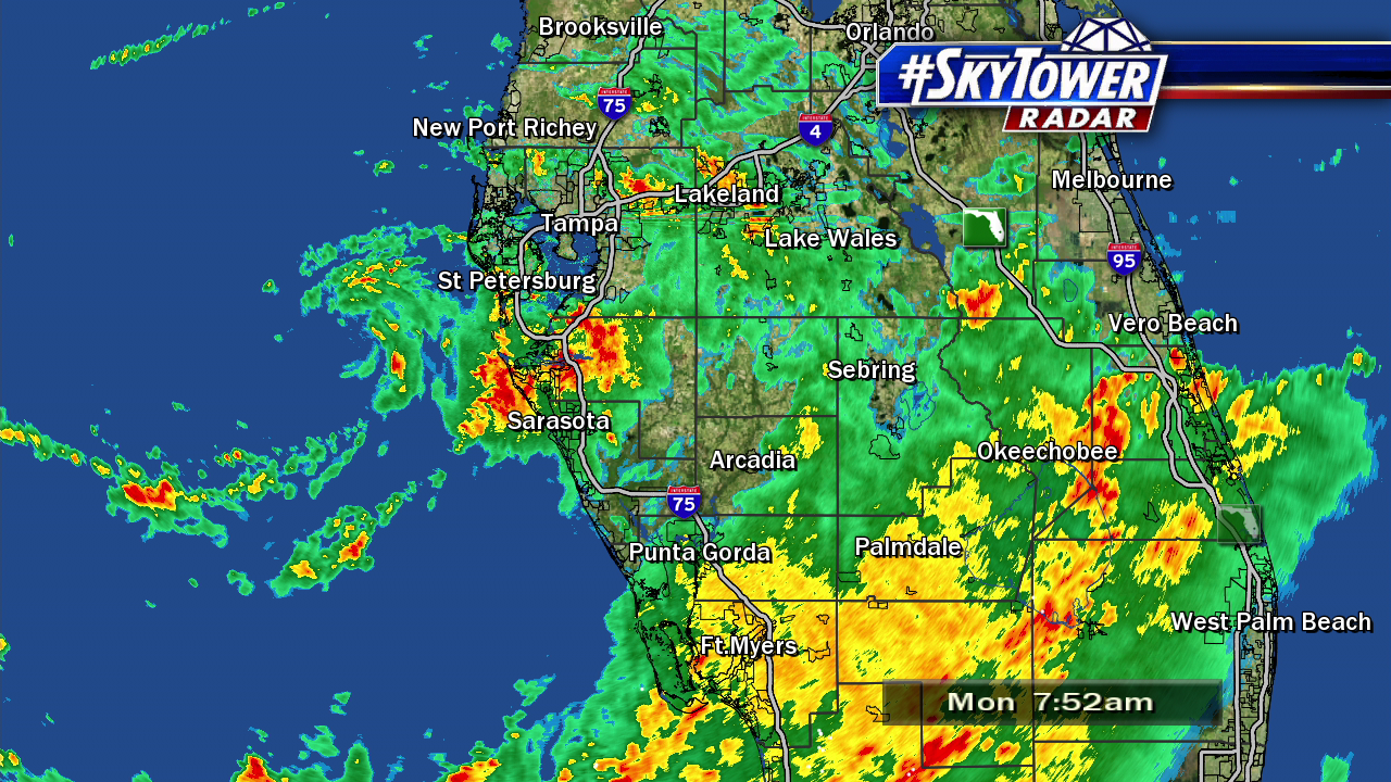
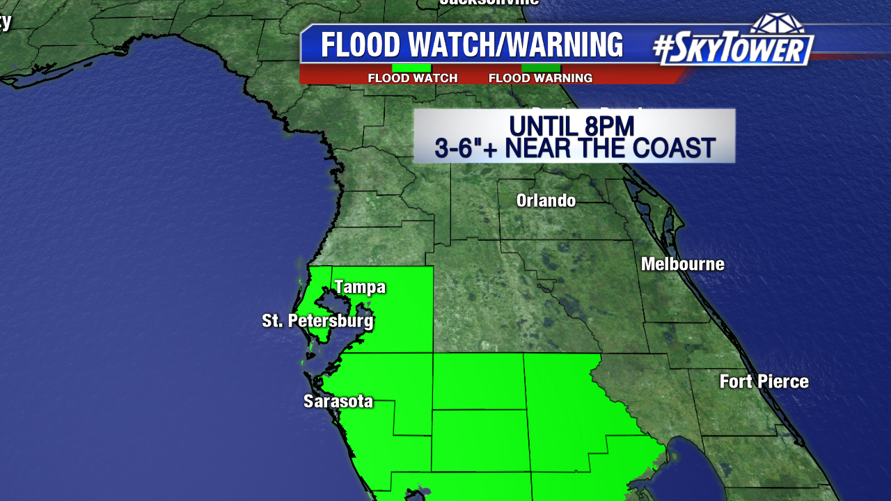
Emily drenched the I-4 corridor southward early Monday.  As of midday Valrico in eastern Hillsborough county saw over 8 inches of rain. St Pete had almost 6″ of rain and Bradenton had nearly 5″.The hardest hit areas were eastern Hillsborough, southern Pinellas, coastal Manatee and coastal Sarasota county. Wrap around moisture will fuel additional downpours through Monday evening as Emily moves east across the area. A Flood Watch is in effect until 8 PM for Hilllsborough, Pinellas, Manatee, Sarasota, Hardee, Desoto and Highlands county. Some rainfall totals may surpass 6″ through Monday evening.

rainfall-totals

lynx

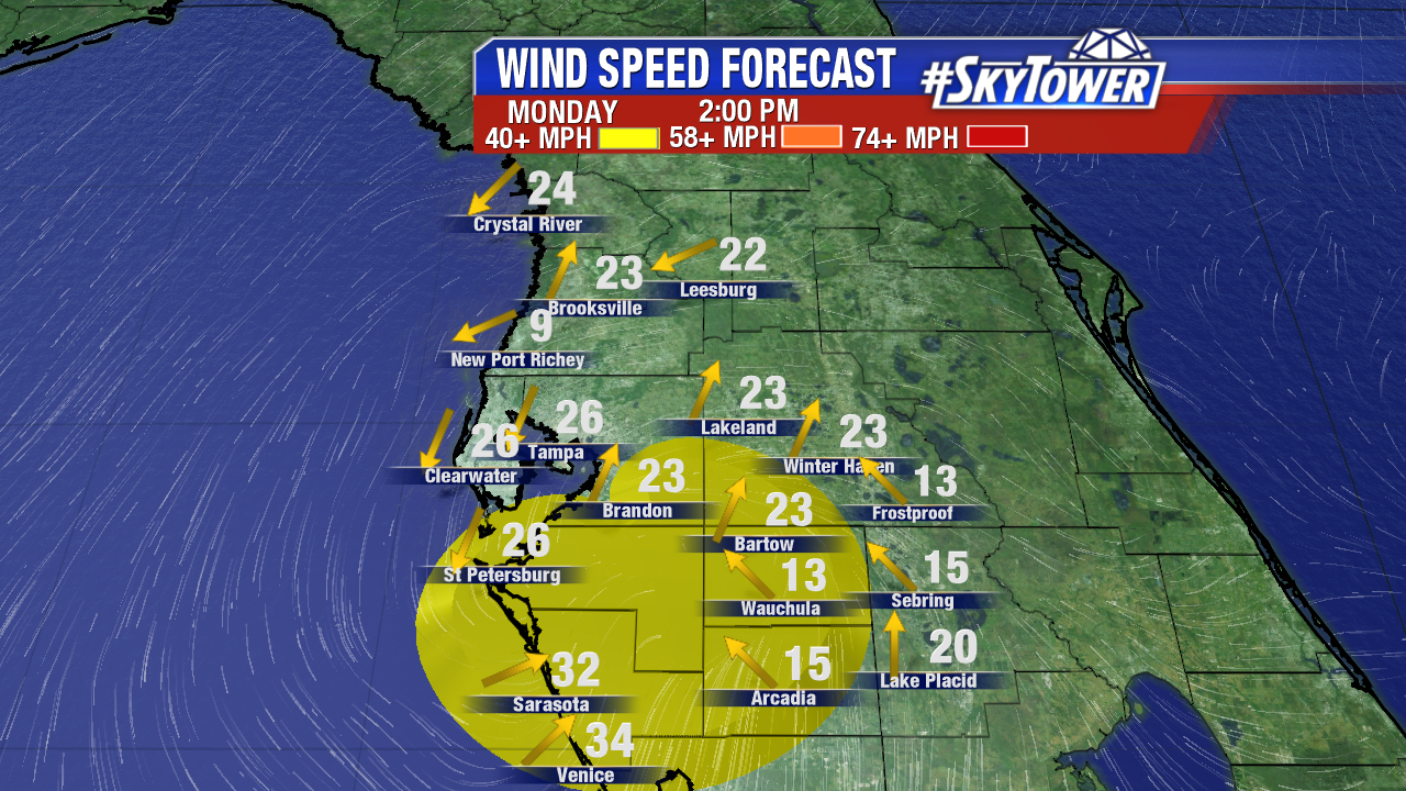
The strongest winds were felt northeast and east of the center of circulation late Monday morning into midday. A wind gust of 57 mph was record at the fishing pier near the Sunshine Skyway Bridge. The Bradenton and Sarasota areas saw gusts near 50 mph, while further north in Tampa wind gusts were less than 20 mph. Wind gusts 30 mph+ are possible through Monday evening as Emily weakens over land and emerges back in the Atlantic early Tuesday.

peak-wind-gusts-2-png-232

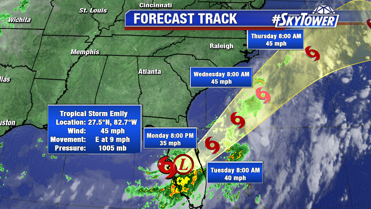
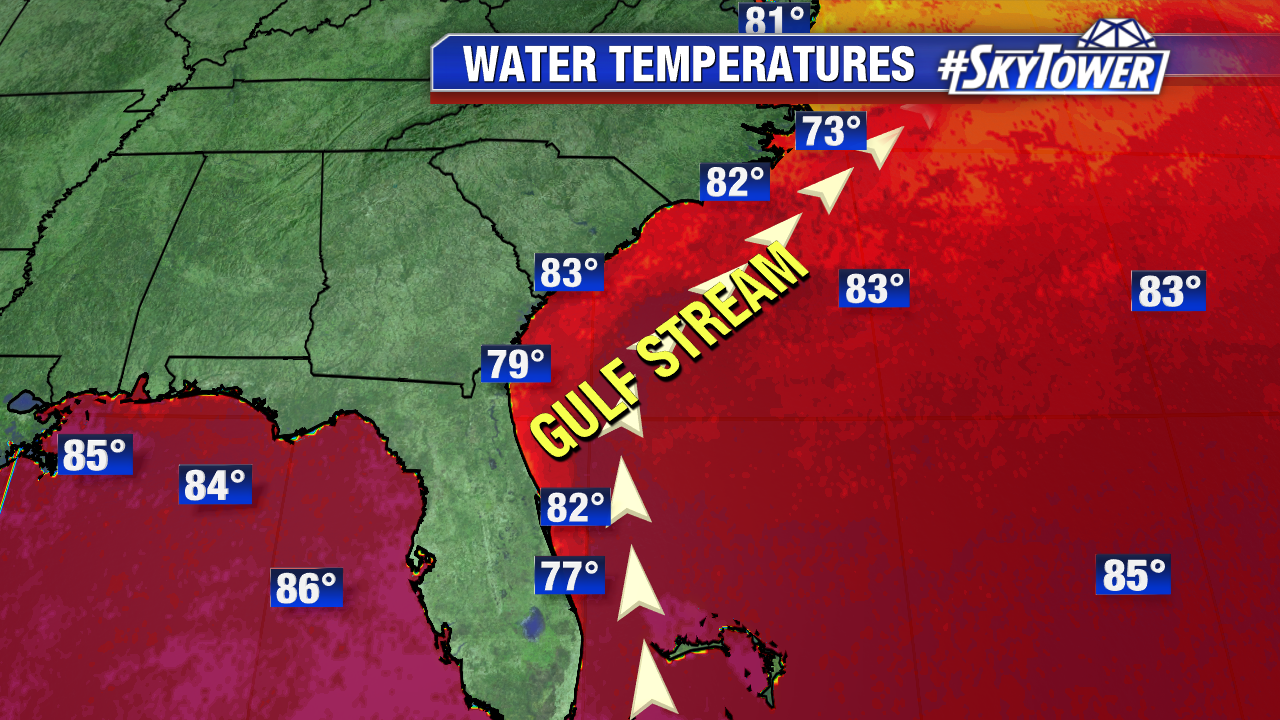
The 11 AM advisory from the National Hurricane Center shows Emily weakening to a tropical depression Monday evening.  It will re-strengthening to a tropical storm and accelerate northeast along a stalled frontal boundary over the warm Gulf Stream waters of the western Atlantic. Wrap around moisture and lingering tropical moisture will fuel scattered tropical downpours in Central Florida Tuesday and Wednesday.

colin

floater-water-temperatures

Tropical Storm Emily Forms West of Tampa Bay; Heavy Rain Threat

Anytime an area low pressure sits over the Gulf of Mexico during the summertime tropical cyclone development can never be ruled out. Despite marginally favorable wind shear, the area of low pressure thrived off of the warm eastern Gulf waters and gained tropical characteristics early Monday. Tropical Depression 6 was quickly upgraded to Tropical Storm Emily at 8 AM. As of 8 AM max sustained winds are at 45 mph. Emily moves east at 8 mph. Tropical storm force winds extend out up to 60 miles for the center. As of 8:45 AM the center is less than 25 miles from the Sunshine Skyway Bridge. Tropical Storm Emily will cut across Central Florida Monday. Training/flooding is likely is spots, especially for Tampa Bay South near the coast. Winds 30-40 mph+ are possible in the strongest squalls. A Tropical Storm Warning is in effect for the Anclote River southward to Bonita Beach. Emily will weaken to a depression and move into the Atlantic early Tuesday.

colin-png343

vipir-png3434

Heavy rain/the potential for flooding is the primary threat from Tropical Storm Emily. A Flood Watch is in effect for Hillsborough, Pinellas, Manatee, Sarasota, Hardee, Desoto and Highlands county until 8 PM Monday. 3-6″ of rain are likely. Some coastal areas will pick up well over 6 inches of rain Monday.

flood-watch-warning-png3434

At times it will be gusty, especially for Tampa Bay South Monday morning and afternoon. Wind gusts will be much lower than they are in a severe thunderstorm in the summertime. Gusts up 30-40 mph+ are possible through Monday afternoon. The strongest wind field is limited to an area around the center.

wind-radii-png3434