Hurricane Irma Strengthens; Caribbean & Possible U.S. Impacts Increasing

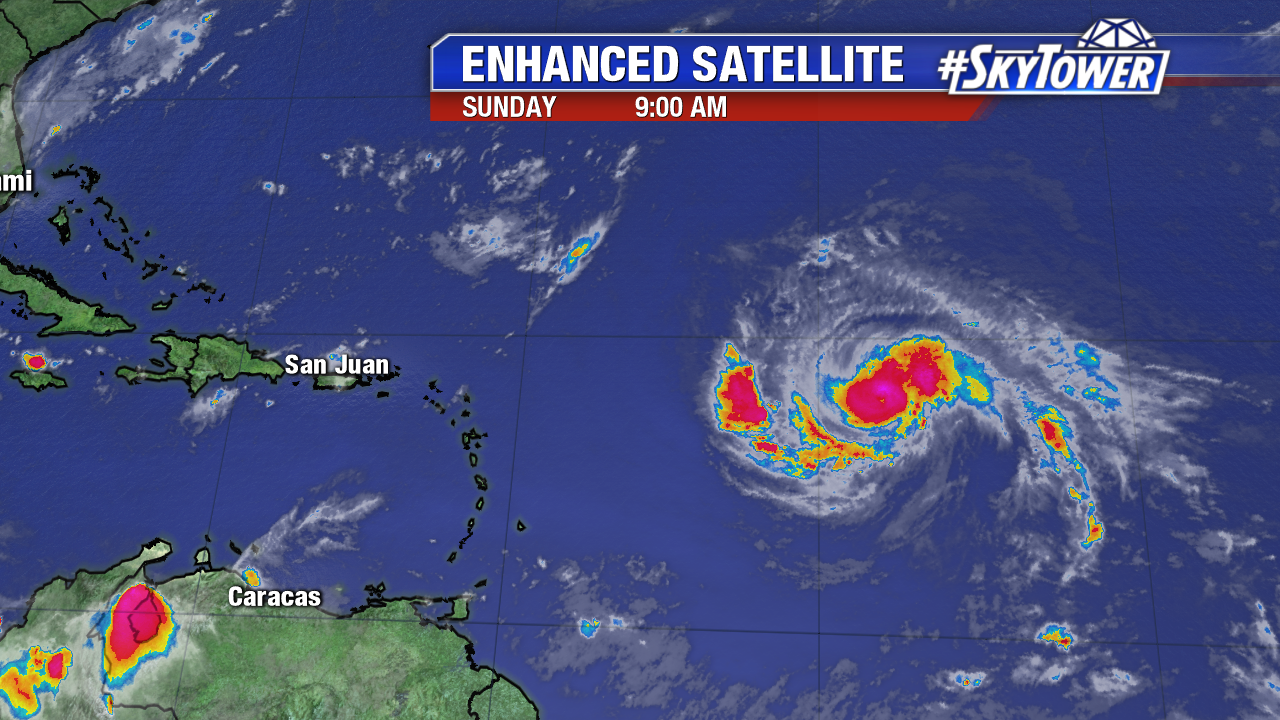
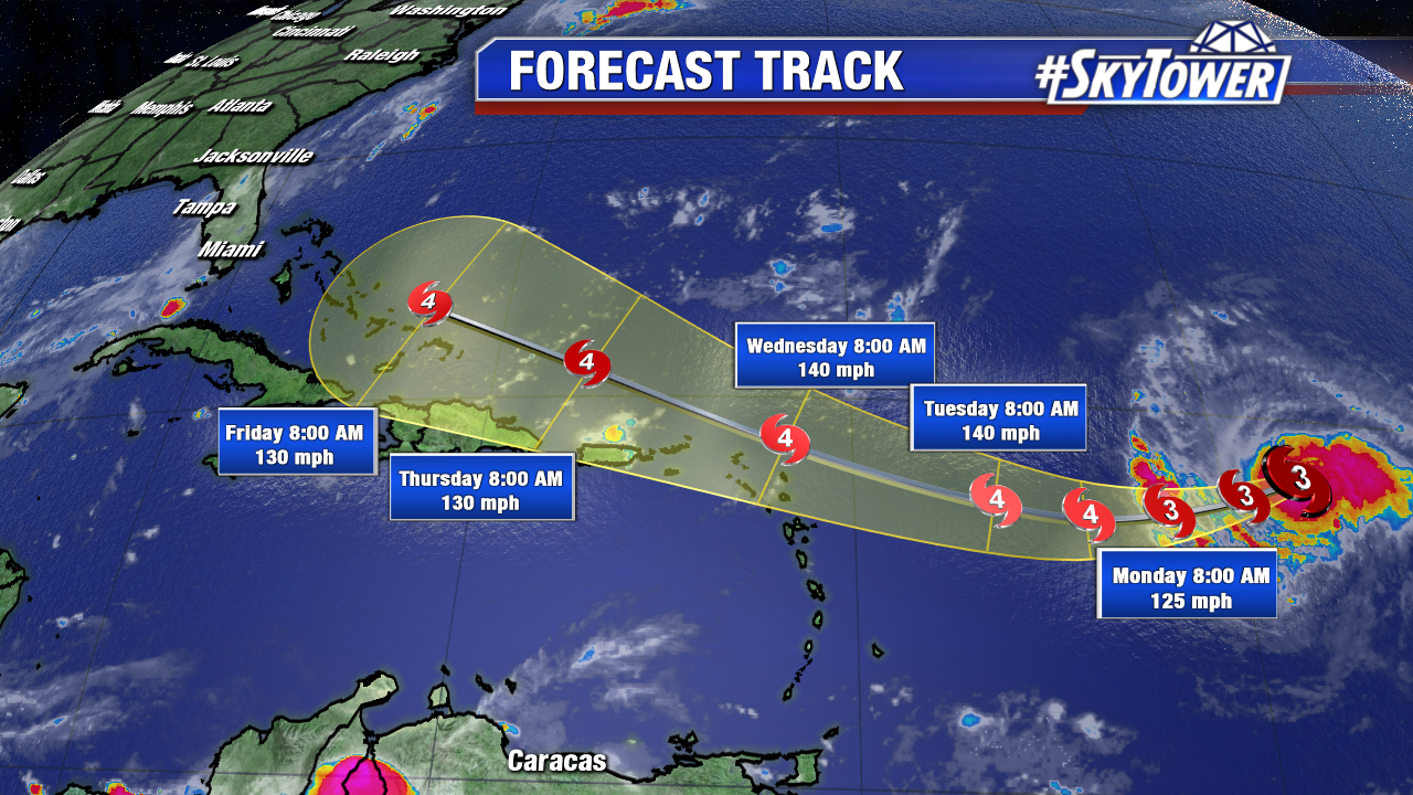
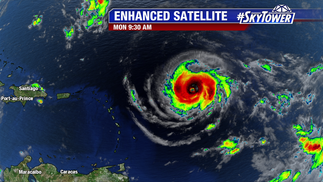
Hurricane Hunter information is essential to fine tuning the future intensity of Irma later this week/this weekend. In Monday morning’s P3 mission the data shows Irma gains strength as it moves west-southwest at 14 mph.  At this pace it will move over, or just north of portions of the northern Leeward Islands early Wednesday. A Hurricane Warning is in effect for Antigua, Barbuda, Anguilla, Montserrat, St. Kitts, and Nevis, Saba, St. Eustatius, and Sint Maarten, Saint Martin and Saint Barthelemy . Pressure steadily drops Monday morning as the major hurricane intensifies. As of 11 AM pressure is down to 944 mb and winds are at 120 mph. As Irma continues to strengthen over a favorable environment its wind field expands in size too. The core of major hurricane force winds extend of 35 miles from its center. The tropical storm wind field now expands 140 miles from the center.

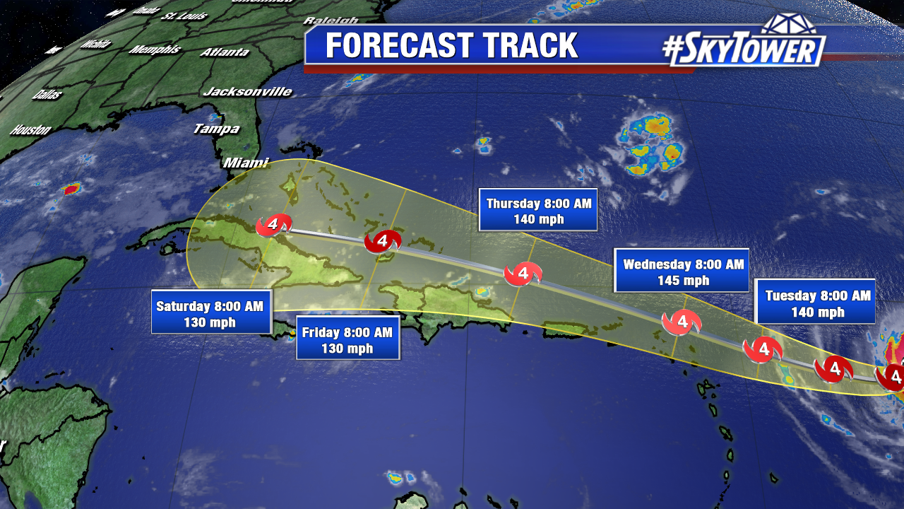
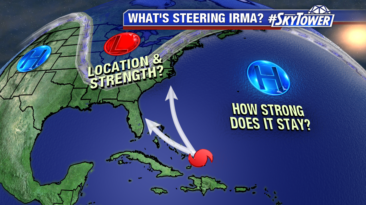
The strong Bermuda high guides Irma west late Monday and Tuesday. If Irma doesn’t gain latitude soon it will track further south and west down the road. The NHC and computer models have trended significantly further south and west since this weekend. Time has slowed a little too. That puts portions of Hispaniola. Cuba, The Bahamas, and eventually Florida in the cone of error. The worst of the storm could pass just north of Puerto, but close by Wednesday and Thursday. A Hurricane Watch is in effect for Guadeloupe, the British Virgin Islands, U.S. Virgin Islands, Puerto Rico, Vieques, and Culebra. A Tropical Storm Watch is in effect for Dominica.  Land interaction, especially with mountainous Cuba and Hispaniola, could disrupt the growing, major hurricane. Keep in mind there a large track error on Day 4 and 5. This is 175 miles on day 4 and 225 miles in day 5. Things can and will change in the coming days. Now is the time be not panic, but stay informed and be prepared.

lynx

irma-png34345

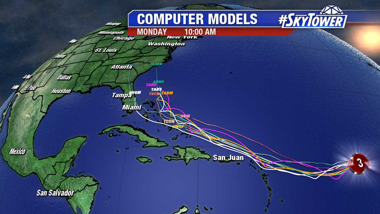
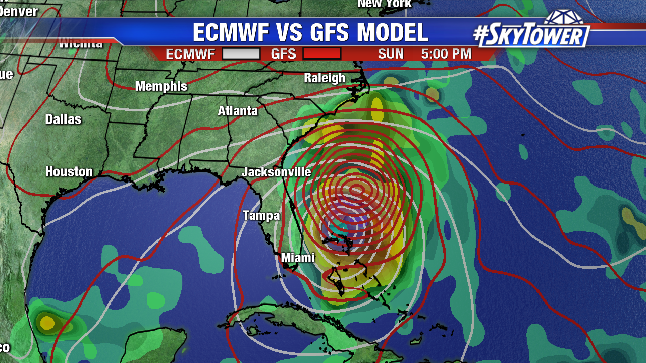
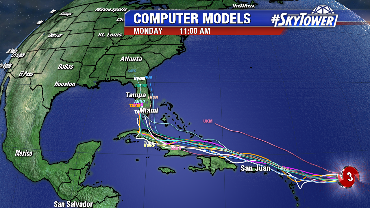
Here’s a look at a significant shift west in early Monday computer models. If this trend continues, South Florida needs to prepare for possible major hurricane conditions Sunday and Monday. Notice the sharp track northward near and eventually over the Sunshine State. While there will be a sharp trough over the East coast, it now appears it may lift out and possibly miss Irma. Instead of the storm heading up possibly out the sea, high pressure may build back in and guide Irma into Florida or somewhere on the Southeast coast. This is a complex upper level setup and small changes will make a big difference in the track. The GFS has jumped on the furthest westward shift. The 06Z has the large major hurricane riding the spine of the Sunshine State. The Euro is west too with a path near southeast Florida and then up into the Carolinas. Stay tuned.

invest-90l-models-png2

explainer-1

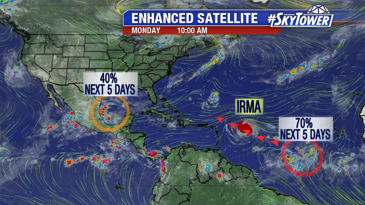
Also of note is a tropical wave on the heels of Irma. It now has a 70% chance of developing over the next 5 days. An area of low pressure is worth watching in the southern Gulf of Mexico. While there is a 40% chance of development the next 5 days, it looks to stay south of flooded coastal Texas.

atlantic-wide-2d-ir-enhanced


hgk

Irma A Category 3 Again Sunday; Slight Westward Shift in Models

Hurricane Irma regains major hurricane strengthens early Sunday as it closes off on drier air aloft.  At 11 AM Sunday the eye has filled as yet another eyewall replacement cycle may be underway.  Some fluctuations in strength may continue over the next day or two. Max sustained winds are at 115 mph at 11 AM. The jog west-southwest is underway at 14 mph. Irma is still less 900 miles for the Leeward Islands, but the official NHC forecast is nudged closer to this region by mid-week. This is in line with a slight westward shift in computer models early Sunday morning. While the core of hurricane force winds extend only 25 miles from the center, the tropical storm wind field expands slowly. The Leeward Islands need to prepare for possible category 4 hurricane conditions Wednesday. Hurricane/Tropical Storm Watches could be issued on Monday. The major hurricane will ride the perimeter of a strong Bermuda High. It takes a northwesterly track late Tuesday, Wednesday, Thursday and Friday near Puerto Rico, Hispaniola, Turks and Caicos, and the Bahamas. Beyond the next 5 days, powerful Irma threatens the East coast of the U.S., including Florida, by late next weekend and early next week. During this time the dangerous major hurricane will be much larger in size too.

Multiple hurricane reconnaissance aircraft with investigate Irma and its surrounding environment starting Sunday afternoon. This data will be ingested into computer models and help with better model consensus. This is key, especially planning ahead for possible U.S. impacts. By Tuesday or Wednesday we will have a better grasp on the long-range track. Now is the time to prepare.

floater-enhanced-satellite-3

irma

Late Saturday computer models trended a bit further east, however that changed early Sunday. A trip out to sea is still a possibility, but numerous models show a major hurricane landfall somewhere on the East coast. A Gulf track is the least likely path at this time.  While the majority of early Sunday computer models, Euro ensembles, GFS ensembles focus in on the Carolinas, there is a very large spread. Florida, the Carolinas and Mid Atlantic need to monitor the forecast closely. According to Dr. Klotzback from Colorado State University, the last hurricane landfall in the U.S. during the month of September is Jeanne in 2004.

invest-90l-models

It is not uncommon for models to flip flop their solutions 7+ out from a possible landfall. The Euro has been back and forth. It was out to sea Saturday, but back into the U.S. near the Carolinas late Monday/early Tuesday. Interestingly enough, the GFS has been very consistent this weekend with a major hurricane in this vicinity by next Monday September 11th. Don’t focus in on a specific model run, but watch trends. Better model data in the days ahead will help us gain clarity on Caribbean and U.S. impacts down the road. Stay tuned.

ecmwf-vs-gfs-mslp-and-precip-rate-png2