Category 5 Irma Brings Destructive Winds and Storm Surge to the Northeast Caribbean; Approaches Florida This Weekend

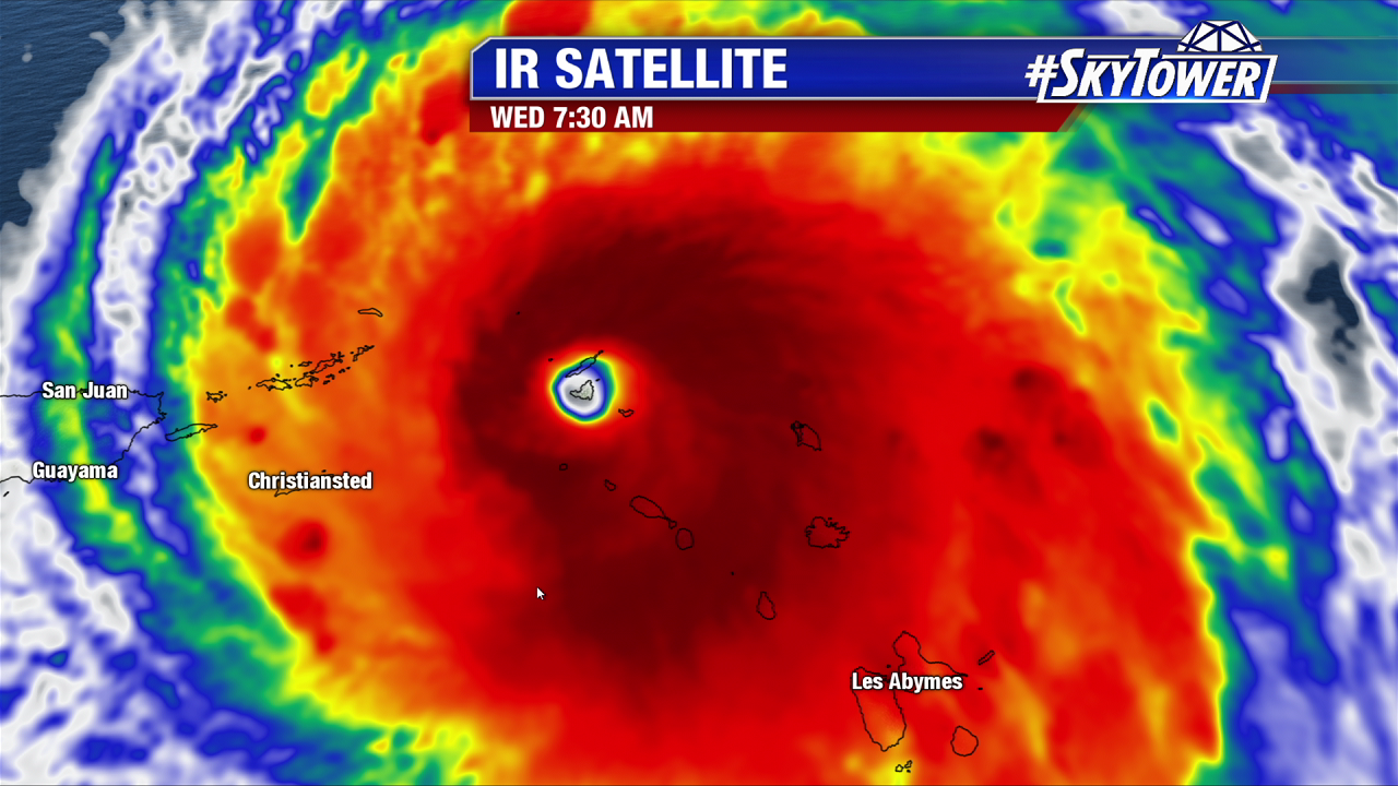
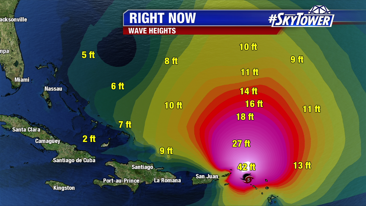
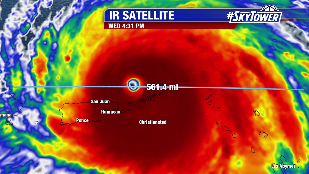
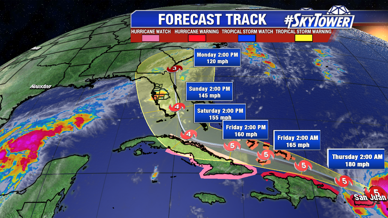
Irma is a beast. After raking the Northern Leeward Islands it slams the British and U.S. Virgin Islands Wednesday afternoon. According to the NHC an unofficial gust of 111 mph was reported on Culebra. The massive category 5 hurricane passes near Puerto Rico early Wednesday evening. The core of hurricane force winds will just skirt the northern part of the island. As of 5 PM it maintains category 5 strength with 185 mph winds as it moves west-northwest at 15 mph. What’s incredible is Irma maintains 185 mph winds for 24 hours+. With the exception of Haiyan in the western Pacific, it is the only Atlantic and Pacific tropical cyclone to stay this strong for this long (according to Eric Blake of NOAA and Dr. Klotzback of Colorado State University). Wave heights build to 30-40 feet just north of the Virgin Islands Wednesday evening. Storm surge batters the eastern Caribbean with a peak surge of 7-11 feet over the Virgin Islands. Impressive waves plow through the Turks and Caicos and the Southeast Bahamas by Friday. A destructive surge of 15-20 feet is possible.

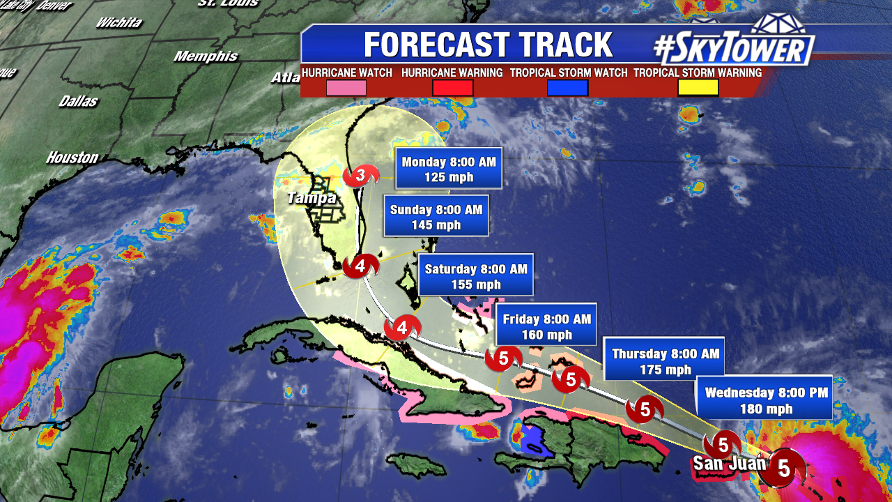
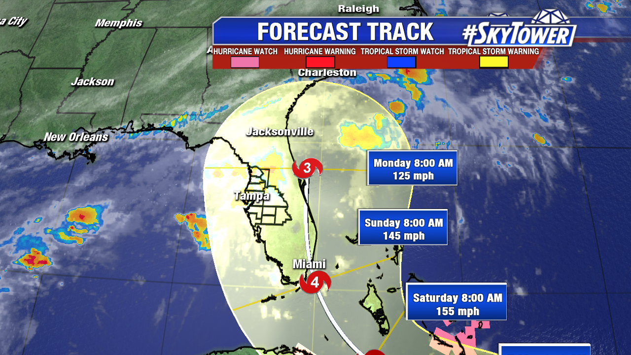
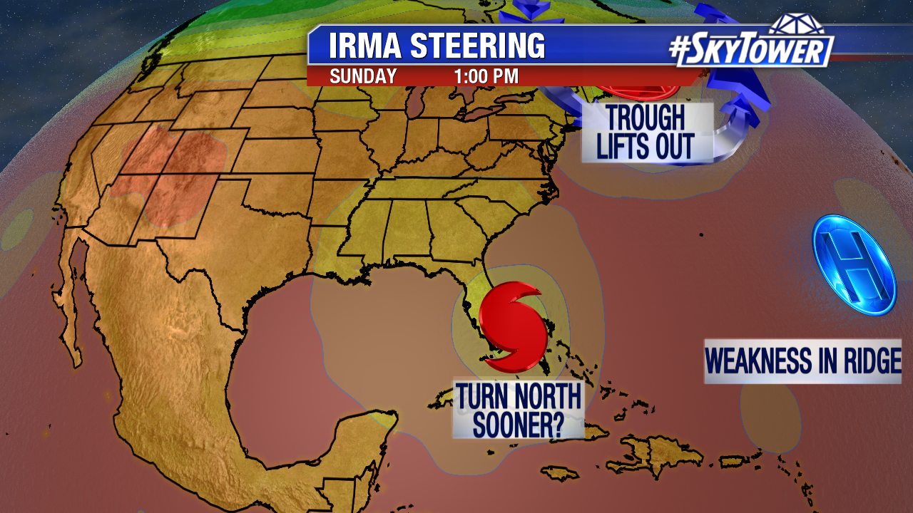
The only thing to really weaken Irma or disrupt it some would be interaction with Hispaniola or Cuba. Even then, the storm would likely still be a dangerous high end major hurricane before possible catastrophic impacts in south and east Florida Sunday and Monday. While the center line from the NHC a little further east at 5 PM, the track error 4 and 5 days out remains the same. 4 and 5 day error is 175 miles to 225 miles respectively. Beyond Florida, it is increasingly likely that coastal Georgia and South Carolina will see impacts too. Impacts are pending on when Irma makes the turn north. At this point, it will be on late Saturday. A slower turn north would mean more impacts a bit further west across the Sunshine State.

lynx-png2223

irma-pngwide

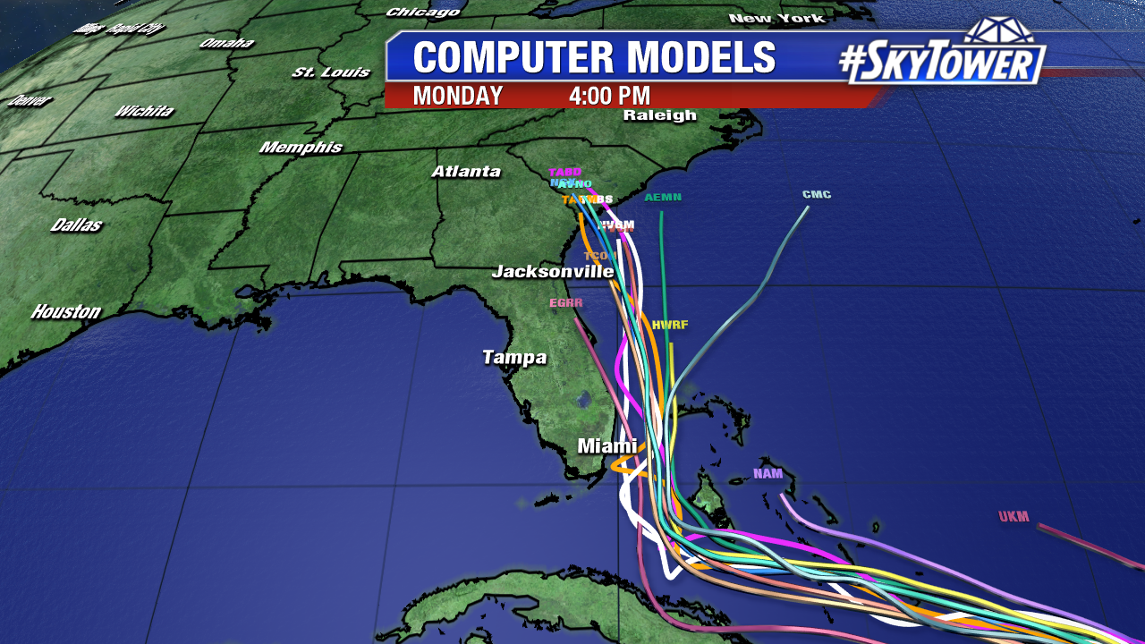
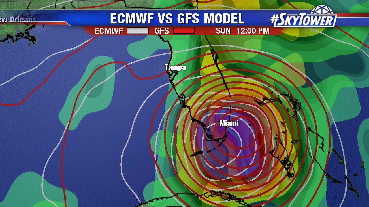
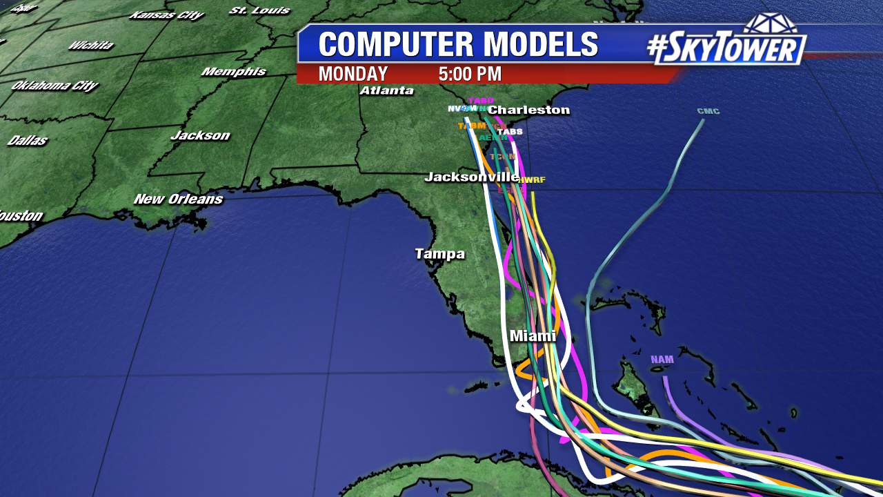
Here’s a glance at some of the model consistency Wednesday afternoon. Notice the cluster of models near southeast and east Florida. This track is northward towards southeast Georgia and South Carolina Monday afternoon. Both the GFS and especially the Euro bring the core of major hurricane force winds near or just over southeast Florida Sunday. A wobble west or east, would make all the difference in widespread destruction or tropical storm winds. Keep in mind as large is Irma is, the structure may not be as symmetrical this weekend. As of 5 PM hurricane force winds extend out 50 miles from the center. The strongest winds are in the surrounding eye wall. Tropical storm force winds extend out up to 185 miles from the center.

ecmwf-vs-gfs-mslp-and-precip-rate

invest-90l-models-png223

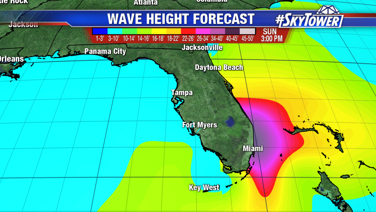
Ridiculous wave heights in the Caribbean move on to Florida by late this weekend. The worst surge, is highly dependent on the track. Here is an early wave height estimate in southeast Florida by Sunday afternoon from Wave Watch III model. Those shades of pink are 25-40 foot waves. Please heed any evacuations and warnings. Stay informed as we gain more model confidence in the days ahead.

floater-wave-heights-forecast

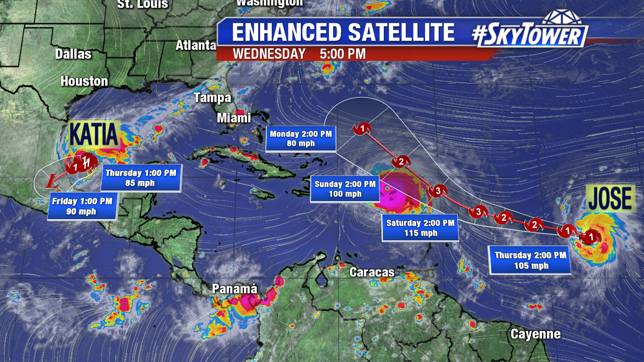
Also of note, both Jose in the east central Atlantic and Katia in the southern Gulf become a hurricane at 5 PM. Jose could clip the Leeward Islands, but should generally stay over the open Atlantic over the next 5-6 days+. Katia will run into mountainous east Mexico this weekend. It will stay well south of Texas.

floater-ir-enhanced

Category 5 Irma Slams the Northeast Caribbean; Models Shift East

Irma is tied for the second strongest hurricane on record in the Atlantic Basin. It is just behind Hurricane Allen, which peaked at 190 mph winds. The Northern Leeward Islands took a direct hit Wednesday morning. Relentless category 5 Irma slams Barbuda, Saint Martin, and Anguila early Wednesday with 185 mph. A NOAA National Ocean Service on the island of Barbuda recorded a gust of 155 mph before it was knocked out. Images from these islands show catastrophic wind damage. Next in the path of Irma are the U.S. and British Virgin Islands Wednesday afternoon followed a close call with Puerto Rico Wednesday night. The storm is massive, its about 500 miles wide, (estimated on GOES 16 enhanced satellite imagery) and impacts are felt well from the center of circulation. Tremendous rainfall and pounding storm surge will batter the northern portions of these islands. 8-12 inches of rain, with isolated amounts up to 20 inches is likely from the Northern Leeward Islands, Northeast Puerto Rico and the British and U.S. Virgin Islands. A catastrophic storm surge of 7-11 feet is expected in these islands too (while north Puerto Rico will see a 4-6 foot surge). Wave heights build to a remarkable 40 feet+ as of late morning Wednesday. Storm surge will be even worse for Turks and Caicos and the Southeast Bahamas as Irma gains latitude later this work week. The concern for Florida and the Southeast U.S. is that these waves lift northward this weekend and early next week. Due to the size and massive flow around Irma, storm surge will be a major issue on the north and east side of the storm. The Keys will get a double whammy as Irma approaches Saturday and then lifts north.

ir-sat

lynx

As of 11 AM max sustained winds are at 185 mph and pressure climbs some to 918 mb. Irma now moves WNW at 16 mph under the perimeter of the Bermuda High. The extent of hurricane force winds will fluctuate some as the storm contracts and goes through eye wall replacement cycles. As of 11 AM hurricane force winds extend out 50 miles from the center. The shield of tropical storm force winds is much larger; these go out 185 miles. Irma will remain a very dangerous category 4 or 5 hurricane over the next 4 or 5 days. Water temperatures are warm and wind shear remains low for at least the next 3 to 4 days. There is a noticeable east shift in the 11 AM advisory. This is in line with an eastward trend in computer models. South/southeast Florida is still very much on track for possible major hurricane force winds, horrible storm surge, spin up tornadoes and heavy rain by early Sunday. This advisory shows the anticipated turn north further east and a bit quicker. The entire state of Florida up through the Carolinas need to stay on high alert for any forecast changes. While the track has shifted east, it is still pretty likely Irma will make landfall in the U.S..

irma2

irma-png3

06Z computer models clearly show an east shift under the influence of a weakness in the Atlantic ridge. While many models keep the center of Irma east of the state, numerous ensemble models still bring this dangerous hurricane up through south and southeast Florida Sunday. If this trend continues, South Carolina could see more impacts by Monday. This trend is a favorable one for the Tampa Bay area. If this holds, storm surge will be a non issue, but heavy rain and tropical storm force winds will still be felt across the area, mainly Sunday and early Monday. Remember the 5 day cone error is more than 200 miles. Things can change. Stay prepared and stay informed.

invest-90l-models

irma-jet-stream