It’s been 35 days since Subtropical Storm Alberto made landfall in the Florida Panhandle. The first named storm of the 2018 season remains the only named storm to date this year anywhere in the Atlantic basin. Not an unusual occurrence given the fact that on average, the second named storm doesn’t form in the Atlantic until August 1st – the first hurricane not until August 10th.
Alberto’s early formation a little more than a month ago had some folks worried we were in for another very active hurricane season, but history tells there is no correlation one way or the other. Not including 2018, a total of 14 years since 1950 have had the first named storm in May. Half of those seasons ended up with above average accumulated cyclone energy or ACE (a measure of tropical activity over the course of a season) and half below average, according to Dr. Phil Klotzbach, a tropical scientist at Colorado State University.
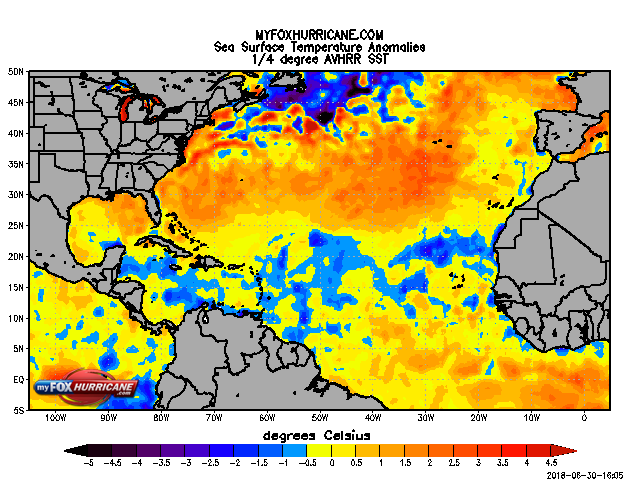
That being said there are some factors that have become increasingly apparent over the last month that point toward a much less active rest of the season. The biggest is the fact that most of the tropical Atlantic continues to have cooler than normal sea-surface temperatures (SSTs) thanks to a persistently strong Bermuda High. This feature, when strong, increases the trade winds across the Atlantic causing increased evaporation and upwelling of cooler water from beneath the surface. Bottom line is, tropical development requires warm water and there isn’t a lot of right now.
It’s certainly possible that we get adequately warm SSTs later in the season, but the expected arrival of El Nino conditions over the next few months will make it harder for storms to spin up in the Atlantic (due to higher wind shear), while further boosting the already very active Eastern Pacific season.
Although signs may point toward a less active season in the Atlantic, remember, all it takes is one storm to make it a bad year. As always, we’ll bring you updates on tropical activity throughout the season, as needed.