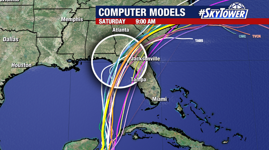
We’re closely watching the progression of Tropical Storm Idalia which continues to meander near the Yucatan peninsula. The storm forming late Sunday morning after Hurricane Hunter data showed it had strengthened from a depression. Idalia is currently impacting the region with heavy rain and gusty winds. The storm likely won’t move much over the next 24 hours as high pressure to the north and Franklin to its east keep it relatively stationary.

By Monday, Idalia is forecast to slowly move north as it’s picked up by a developing trough to the west of the storm and a building ridge to the east.

Models are beginning to come into agreement on a track to our west but there remains a high degree of uncertainty regarding how close the system comes to the Tampa Bay area. Everyone along Florida’s Gulf coast should prepare for potentially significant impacts from this storm, whether direct or indirect.

We’re also seeing a signal for a stronger storm on approach that is likely to reach hurricane strength before landfall and a strong hurricane isn’t off the table. Water temps are exceptionally warm in the southern Gulf and Idalia is expected to be fueled by generally favorable conditions for intensification.

It’s important to remember that local impacts will depend on the exact strength of the storm and where exactly it goes. Tens of miles will make a difference. At this point, it’s fair to say tropical downpours and squally weather could begin late Tuesday through Wednesday with the worst weather along the coast. Strong winds could lead to power outages as well as storm surge and coastal flooding, especially during periods of high tide. Stay tuned for updates.

